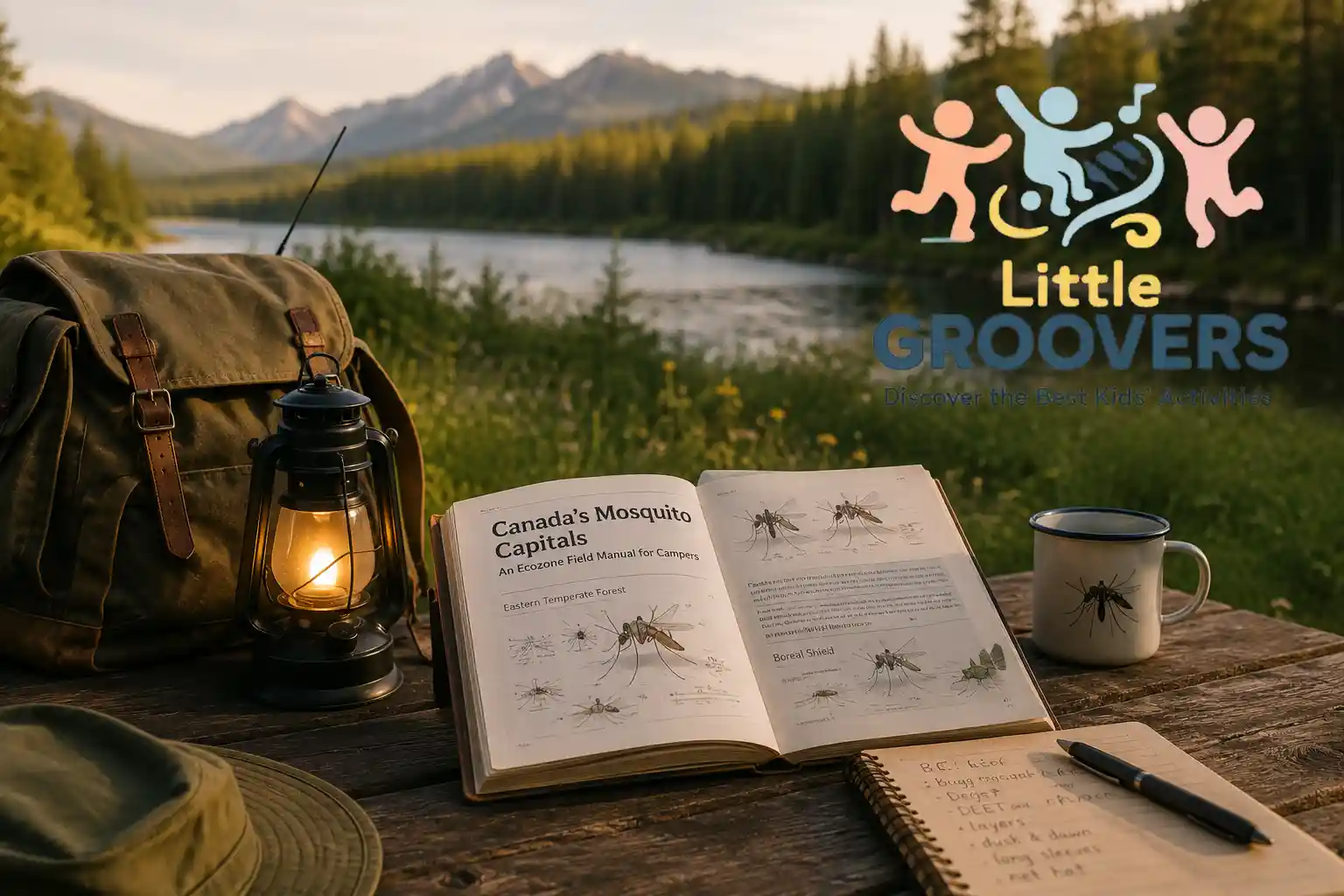
The first black flies hit just as you shoulder the canoe. Within ten minutes, the landing rate jumps from a manageable handful to a swarm so dense you are inhaling them. You slap, you miss, and you fumble the portage. By the time you reach the next lake, your neck is a braille map of welts and your partner is asking, quietly, whether you should just go home.
That trip ended at the put-in, not because of weather or water, but because we walked blind into a floodwater hatch we could have seen coming a week in advance. At Little Groovers, we plan family time outdoors around data rather than luck, and a mosquito hatch is one of the most predictable variables you can prepare for.
Key takeaways
Mosquito pressure in Canada is not uniform; it is an ecozone-specific, seasonally predictable threat.
A ruined trip is often the result of ignoring local hatch timing and surveillance data.
This article delivers a field manual: ecozone maps, Health Canada-backed defence, and real-time dashboards.
Climate change is extending mosquito seasons, which makes old assumptions dangerous.
To put a number on it, a few seasons ago we booked the May long weekend on a Boreal Shield lake without once checking a trap count. The forecast looked perfect and the lake was beautiful. What we did not see was that ice-out had come early, the floodwater hatch was already running two weeks ahead of schedule, and by our second evening the landing rate at the fire pit made cooking impossible. We packed up at first light on day two and drove home a full day early, scratching the whole way. That trip was not ruined by bad luck. It was ruined by a five-minute check we never made.
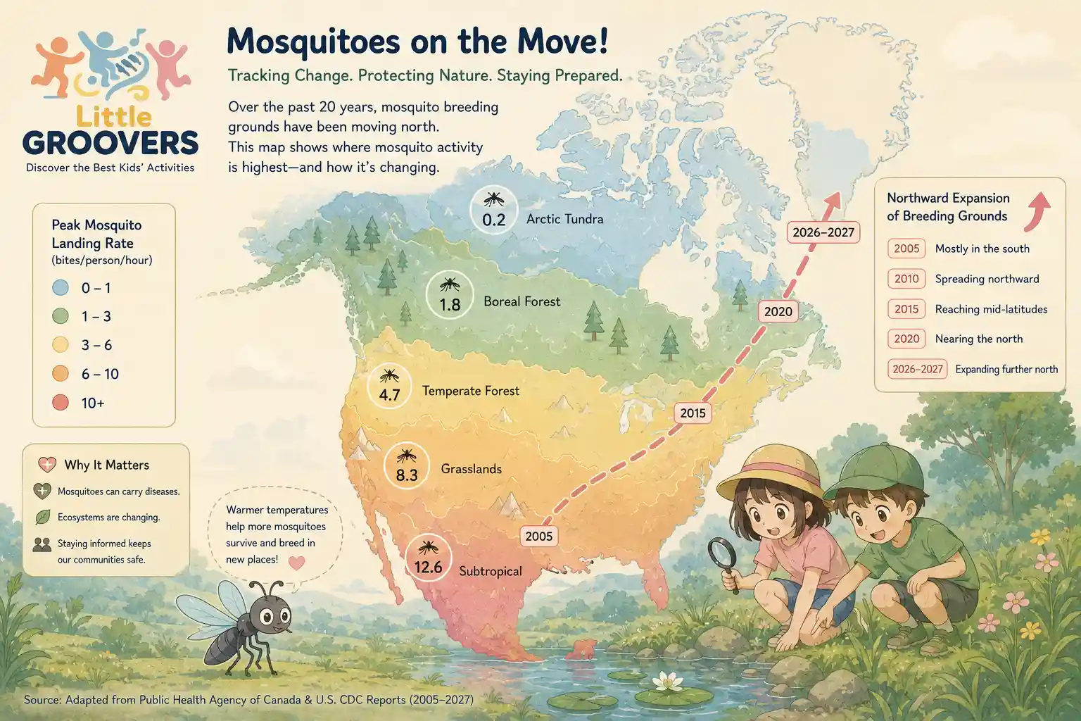
Canadian campers and cottagers are navigating a landscape where the stakes have quietly risen. According to the Climate Atlas of Canada, mosquito-borne disease risk has climbed roughly 10 percent over the past two decades, and warming trends are pushing vector species into new territory with longer active seasons. The old rule of thumb, that June is bad and August is fine, no longer holds.
What you need instead is a seasonally precise, geographically grounded understanding of the threat. Not generic advice, but ecozone-specific intelligence: which species dominate where, when their peak landing rates hit, and how to read the surveillance dashboards that public health units already maintain.
This article is that field manual. It replaces provincial guesswork with a practical framework built on Health Canada science, trap-count data, and the real-world patterns that decide whether a trip is memorable or miserable. We start by mapping the worst zones, not by province, but by the ecological boundaries that actually govern mosquito life cycles. If you are still choosing where to go, our roundup of the best family road trip destinations in Canada pairs well with the timing advice below.
Where the Swarms Rule: Geographic Risk Mapping by Canadian Ecozone
To plan a trip that does not end behind a screen door, you need to read the landscape by ecozone, not by province. Provincial boundaries are political lines drawn on a map; they cut across boreal forest, prairie wetland, and tundra with no regard for the hydrology that fills a mosquito's breeding pool. A trip planner who thinks in terms of Ontario in June has already made a category error.
The mosquito pressure in a southwestern Ontario fen shares almost nothing with the pressure in a northwestern Ontario boreal swamp, and neither resembles the urban heat island of Toronto. The practical unit of risk is the ecozone: a distinct ecological region defined by climate, landforms, and vegetation. Once you learn to read the country this way, the swarm stops being a generic menace and becomes a predictable feature of the terrain.
Beyond Provincial Borders: Why Bioregions Matter More Than Province Names
Provincial labels mislead because they collapse radically different habitats under a single name. Manitoba contains both the open prairie pothole country and the Precambrian Shield's black spruce bogs. Quebec stretches from the St. Lawrence lowlands to the treeless Subarctic. A camper who checks a provincial mosquito forecast and sees a moderate rating may drive six hours north into an ecozone where the landing rate is an order of magnitude higher.
The only way to align your expectations with reality is to consult the surveillance dashboard for the specific health unit that covers your destination, then cross-reference that data with the ecozone you will be sleeping in.
Ecozones group land by shared hydrology, soil chemistry, and vegetation: the three variables that decide which mosquito species will breed, how many broods they can squeeze into a season, and how long the adults persist. A temporary pool in the Prairie Pothole ecozone fills with snowmelt in April and dries by July; it produces a single, staggering floodwater hatch of Aedes species and then goes quiet.
A sphagnum bog in the Boreal Shield holds water all summer, acidifies it, and supports a staggered sequence of hatches from May through September. The difference in bite pressure between those two sites, even if they sit at the same latitude, is not subtle. It is the difference between a bad weekend and a trip you abandon.
The Boreal Shield, Canada's Engine of Abundance
The Boreal Shield is the country's most consistently punishing mosquito zone. Stretching from the Ontario and Quebec border region across the Canadian Shield's bedrock basins, this ecozone combines thin, acidic soils with an almost unbroken sheet of standing water: beaver ponds, peat bogs, shoreline marshes, and the countless ephemeral pools that form in rock depressions after every rain. Water does not drain here; it sits and acidifies, creating exactly the conditions that Aedes species exploit.
Surveillance work in the Ontario Shield and Hudson Bay Lowlands has recorded 19 mosquito species, 16 of them Aedes, a diversity that translates directly into sustained bite pressure because different species peak at different times.
The early-season player is Aedes canadensis, the woodland pool mosquito, which breeds in transient water and sphagnum bogs and is distributed across the Shield and into the Northwest Territories. It emerges as soon as the ice leaves the pools, often while snow still lingers in the bush.
Later broods layer on top: more Aedes species, plus Anopheles and Coquillettidia, filling the gap between spring and fall. The result is not one hatch but a relay race of hatches that keeps landing rates high from late May through August. A brief mid-summer dip occurs only if a dry spell holds long enough to desiccate the shallow pools. And in the Shield, that is a big if.
I still remember a mid-June portage through a Boreal Shield lowland where the landing rate climbed past 50 per minute. You could hear the swarm before you felt it, a thin, constant whine that never broke. Every breath had to be taken through clenched teeth, and the cloud was thick enough that the far end of the portage trail blurred behind it. A head net stopped being optional and became the only way to keep my eyes and mouth clear. The pack felt twice as heavy, because every pause to rest invited another wave, so we simply did not pause. That stretch taught me, more than any chart could, why the Shield earns its reputation.
Prairie Potholes and Wetland Corridors
The Prairie Pothole ecozone, running through southern Manitoba and Saskatchewan, operates on a completely different clock. Here the landscape is a mosaic of shallow depressions (potholes) left by retreating glaciers, plus seasonal sloughs and agricultural drainage ditches. These basins fill with snowmelt in April, and the eggs of floodwater Aedes species, laid on dry soil the previous summer, hatch in a synchronized explosion.
The hatch is not gradual; it is a floodwater hatch, and it can transform a calm prairie campsite into a no-go zone inside 48 hours.
The intensity is ferocious but brief. Prairie potholes warm quickly and begin to dry as soon as the spring runoff stops. Many basins are ephemeral, holding water for only a few weeks. The mosquito pressure peaks sharply in May and early June, then collapses as the breeding sites evaporate.
By July, the same campsite may be nearly mosquito-free, though the vacuum is often filled by biting flies, which thrive in the same wetland corridors. Trip planners who understand this pattern can target the post-hatch window and experience the prairies at their best, while those who arrive blind during the peak may find themselves retreating to the truck.
Subarctic Compression: The Short but Savage Season
Northern Quebec, the Yukon, and the Northwest Territories compress the entire mosquito season into a three-to-four-week window of extraordinary intensity. The trigger is rapid snowmelt across vast, flat terrain with poor drainage, which creates a near-continuous sheet of shallow breeding water just as the sun begins its 24-hour cycle. In these subarctic ecozones, there is no night to suppress mosquito activity.
Aedes species, adapted to the short season, emerge in staggering densities and remain active around the clock, driven by the unending daylight of June.
The misery is real, but so is the relief. By late July, the initial brood has largely died off, and the cooler nights that return in August suppress further hatches. A trip timed for early August can be almost pleasant, while a trip in mid-June demands full coverage, a head net, and a mental readiness that most southern campers have never needed to develop. The Subarctic does not produce a long season; it produces a savage one, and then it stops.
The Kawartha Lakes and Great Lakes to St. Lawrence Clockwork
Southern Ontario's cottage country sits in a mixedwood plain ecozone where the mosquito season starts earlier, runs longer, and repeats itself more often than in the Shield. The difference is hydrology. Canal systems, reservoir edges, rice paddies, and the margins of the Trent-Severn Waterway create permanent or semi-permanent shallow water bodies that do not dry out in summer.
These sites support multiple broods of both floodwater and standing-water species, including Culex mosquitoes that become active later in the season and serve as bridge vectors for West Nile virus.
Cottage country remains overwhelmed despite its proximity to towns with municipal spray programs. Spray trucks can reduce adult populations along roadsides and in parks, but they cannot reach the thousands of private docks, back bays, and wetland edges where breeding occurs. If a trip turns buggier than expected, it helps to have a daytime alternative ready, and our guide to the best parks and playgrounds in Ottawa lists breezier, open spaces that families can fall back on.
The result is a patchwork: a campsite in a managed provincial park may feel tolerable, while a rental cottage on an unsprayed lake two kilometres away can be under heavy bite pressure. The surveillance dashboards for local health units often reveal this granularity, and they are worth checking even for a weekend trip.
Western Boreal and Montane Transition Zones
Alberta and the western fringe of the boreal plain introduce elevation and wind as modifiers of mosquito pressure. In the montane transition zones where the boreal forest meets the Rockies, valley bottoms can hold dense swarms while ridgeline campsites stay clear, simply because cold air drainage suppresses adult activity and wind corridors disperse them.
River deltas, such as the Peace-Athabasca, concentrate breeding habitat in a way that creates localized swarm pockets, intense but geographically tight. A trip planner who understands these micro-controls can select a campsite on a breezy bench rather than a sheltered oxbow and experience a completely different night. For families based in Alberta, the same wind logic applies closer to home, and our list of the best parks in Calgary highlights open, breezy green spaces for low-pressure outings.
The species mix in these western zones still leans heavily on Aedes, but the seasonality is more compressed than in the eastern Shield, with a pronounced spring peak and a faster decline into summer. Elevation buys you time: a campsite at 1,200 metres may see hatch onset two weeks later than one at 700 metres, a delay that can align a trip with the post-peak window.
With the geography mapped, the next step is timing: when each zone erupts.
The Calendar of Discomfort: A Seasonal Hatch Timeline by Bioregion
Knowing where the swarms live is half the battle; knowing when they hatch is the other. Canada's mosquito season is not a single event but a cascade of emergences timed to snowmelt, soil temperature, and rainfall. Each ecozone follows its own clock. A warm April on the Prairies can compress the floodwater hatch into the first week of May, while the same latitude in the Boreal Shield holds its peak until June. This section maps that calendar so you can read the landscape before you pack.
Reading the Thaw: From Snowmelt to First Bite
The trigger for the season's first wave is not a date on the calendar. It is soil temperature. Floodwater Aedes eggs, laid the previous summer on dry ground in low-lying basins, require a precise sequence: a winter freeze, a spring thaw that saturates the soil, a brief dry-down that cracks the egg casing, and then a re-wetting from rain or snowmelt runoff. When that final inundation arrives, millions of larvae hatch in synchrony.
In southern ecozones like the Prairie Pothole and Mixedwood Plains, a warm April can accelerate this sequence dramatically. Soil temperatures climb past around 7 degrees Celsius weeks earlier than the long-term average, and the first standing water appears in ditches and sloughs. The result is a compressed hatch that can push biting activity into the first week of May.
Farther north, in the Boreal Shield and subarctic, the ground remains frozen well into May, and the initial pulse waits until late May or early June. The rule is simple: the earlier the thaw, the earlier the first bite.
The June Explosion: Floodwater and Spring Aedes Hatches
June and early July are the non-negotiable danger window for the Boreal Shield and Prairie Potholes. This is when the floodwater phenomenon reaches its peak. Eggs that survived the winter in dry basins hatch explosively after a single heavy rainfall or sustained snowmelt recharge. Within 48 hours, a dry trail corridor can become a gauntlet of aggressive, day-biting Aedes.
The Boreal Shield adds a second layer of persistence. Aedes canadensis, the woodland pool mosquito, breeds not only in transient floodwater but also in the sphagnum bogs that dot the Shield. These bogs act as slow-draining nurseries, extending the spring bite window well into June even in years with average snowmelt. A trip that looks clear on a dry June 1 can turn brutal by June 3 after an overnight rain recharges those bog pools.
On one early June trip the trails were bone dry when we set out, and the first afternoon was almost mosquito-free. Then it rained overnight. By the next midday those same dry corridors had become a gauntlet: the bog pools had recharged, a fresh brood had hatched, and within 48 hours of that single rainfall the bite pressure had tripled. We cut the loop short and retreated to a breezy point by early afternoon, watching the swarm thicken behind us in the still air of the lowland we had just left.
The landing rate in these conditions can exceed 20 per minute at peak. That is not a nuisance; it is a field hazard that forces you to rethink your route or your timeline.
Mid-July Lulls and Late-Summer Resurgences
By mid-July, the spring Aedes species begin to decline. Their breeding pools dry up, and the adults that emerged in June reach the end of their lifespan. Many campers notice a welcome lull.
But this dip is temporary and regional. In the Prairie Pothole and Mixedwood Plains, summer Culex species are already ramping up, laying egg rafts in permanent standing water. By late July and August, Culex tarsalis and Culex pipiens become the dominant biters.
This late-summer window matters for more than comfort. Culex species are the primary bridge vectors for West Nile virus in Canada. Surveillance trap counts for Culex spike in August, and health units watch these numbers closely. The 10 percent increase in mosquito-borne disease risk over the last 20 years, documented by the Climate Atlas of Canada, is partly driven by earlier spring thaws and later fall frosts that stretch the Culex season. A warm September now extends biting activity into weeks that were once frost-quiet.
Subarctic Timing: Why Late July and August Are Your Safer Windows
For travellers heading to the subarctic, the calendar flips. The explosive floodwater hatch that defines June in the Boreal Shield hits the subarctic in late June and early July, when the tundra and taiga finally thaw. Swarms are intense but short-lived. By late July, the peak has passed, and August offers a meaningful drop in bite pressure.
Target late July and August for subarctic trips. You will still face mosquitoes, but the densities are manageable with a disciplined defence protocol. The trade-off is real: the subarctic window is narrower, but the swarms during that peak demand maximum protection. A July 1 trip into the barrens without a head net and full-coverage clothing is a decision you will regret within minutes.
Using Real-Time Dashboards to Adjust Plans on the Fly
Provincial health units and some municipalities now publish surveillance dashboards with weekly trap-count updates. These dashboards report landing rates, species identification, and sometimes disease-positive pools. Before a trip, check the dashboard for your destination ecozone. A spike in Aedes trap counts in late May tells you the floodwater hatch is under way. A rising Culex count in August signals the late-summer resurgence.
Interpret the numbers practically. A landing rate of 5 per minute is annoying; 15 per minute is trip-altering. If the dashboard shows a sudden jump after a rainfall event, delay your departure by a few days or pack an extra layer of defence. The data is public and updated weekly. Use it.
Forecasting Feeding Activity: Humidity, Temperature, and Wind
Mosquito feeding activity is not constant. It is governed by microclimate. Calm, humid evenings with temperatures above around 15 degrees Celsius are feeding frenzies, especially for crepuscular species like Aedes and Culex. Sustained breezes above 6 km/h suppress flight and landing. A windy ridgeline can be a refuge on an otherwise brutal evening.
Check a weather app that reports wind speed and humidity, not just temperature and precipitation. If the forecast calls for a still, muggy dusk, plan to be inside your shelter or fully geared up before the sun drops. If a steady 10 km/h breeze is predicted, you can relax your protocol slightly. This is not guesswork; it is reading the conditions the mosquitoes themselves read.
Timing your trip is critical, but understanding which species are biting, and what they carry, determines your defence posture.
Vectors vs. Nuisance Biters: Understanding Species-Specific Health Risks
Not all bites are equal. The species mix in your ecozone dictates whether you are dealing with an itchy nuisance or a genuine health risk. A spring Aedes floodwater hatch can push landing rates past around 20 per minute, yet none of those mosquitoes carry disease. A single Culex tarsalis feeding at dusk, barely noticed, can transmit West Nile virus. Knowing which genus owns the airspace changes everything.
Canada's mosquito genera split neatly into two camps: the aggressive nuisance biters and the quiet vectors. Spring Aedes, the architects of the floodwater hatch, are the ones you feel. They emerge in staggering numbers after snowmelt or heavy rain inundates their dormant eggs, and they hunt by sight and scent in broad daylight. Their bite is immediate and persistent, but they carry no pathogens of concern to humans. They are a comfort problem, not a health problem.
Culex mosquitoes, particularly Culex tarsalis on the Prairies and Culex pipiens or restuans in the east, operate differently. They are crepuscular, feeding most actively in the hour after sunset and again before dawn. You rarely notice them because their flight is silent and their bite is light.
That stealth matters: Culex tarsalis is a bridge vector, feeding on birds where West Nile virus circulates and then on humans, which links the enzootic cycle to your bloodstream. Its breeding sites are not floodwater pools but stagnant, organically rich water: ditches, catch basins, and neglected bird baths.
If you are swatting mosquitoes at noon, you are almost certainly dealing with Aedes. If you are unprotected at dusk near standing water, you are in Culex territory.
Anopheles species, the malaria vectors elsewhere, are present in Canada but epidemiologically silent. A few species bite indoors and outdoors, but they are not currently implicated in local disease transmission. Their presence is a footnote, not a threat.
This behavioural split dictates defence. Daytime Aedes swarms demand physical barriers, tight-weave clothing, and head nets, because repellent alone can feel overwhelmed. Evening Culex risk demands disciplined repellent application and a hard stop on exposed skin during crepuscular hours. Species identification, even at the genus level, turns a generic bug season into a manageable risk profile.
West Nile virus is also worth understanding as a parent, because its early symptoms in children can look like an ordinary summer fever. Most cases are mild, but if a child develops a high temperature within a couple of weeks of heavy exposure, it helps to know what counts as a fever and when to act, which our guide to fever and temperature taking in children walks through step by step.
West Nile virus activity in Canada is not evenly distributed. It concentrates in the Prairie Pothole ecozone, southern Manitoba, Saskatchewan, and Alberta, and in southern Ontario's agricultural and urban corridors. Manitoba Health surveillance in recent seasons has reported Culex tarsalis positive pools across multiple health regions, along with human cases.
The Public Health Agency of Canada's national surveillance dashboard tracks these positive mosquito pools weekly, which gives you a real-time picture of where the virus is actively circulating. If you are planning a trip to the Interlake or the Red River Valley, that dashboard is not background noise; it is a decision tool.
The night before a trip to the Interlake, I pulled up the Manitoba Health mosquito surveillance page and saw Culex tarsalis trap counts climbing across the region. That single number changed our evening plan. Instead of lingering by the water after sunset, we ate early, moved everyone into screened shelter before dusk, and saved the repellent for the short walk back. Nobody was bitten at the worst hour of the day, and it cost us nothing but a glance at a public dashboard.
Eastern equine encephalitis (EEE) remains a rare but severe threat that is largely confined to Ontario. Human cases outside that province are extremely uncommon. The virus cycles between birds and Culiseta melanura, a mosquito that rarely bites humans, but bridge vectors like Coquillettidia perturbans can move it into people. The risk is low, but the outcome is grave, because EEE carries a high case-fatality rate. For campers in southern Ontario's hardwood swamp country, awareness of EEE adds a layer of caution that generic mosquito advice misses.
The takeaway is blunt: if your ecozone sits outside the Prairie Pothole or southern Ontario, your mosquito problem is overwhelmingly a nuisance problem. Inside those zones, the evening bite carries a genuine health risk that demands surveillance-informed timing and protection.
Mosquitoes Rarely Arrive Alone: Black Flies and Ticks
Mosquitoes rarely arrive alone in Canadian ecozones. In the Boreal Shield, a June evening can deliver a trifecta: black flies swarming your face, Aedes mosquitoes working your ankles, and blacklegged ticks questing in the leaf litter you walked through to reach the campsite. Each demands a different defence, and the wrong combination can leave a gap.
Black flies are daytime swarmers that target the head and neck, and they often defeat standard mosquito repellents. Their peak overlaps with the spring Aedes hatch, so a head net becomes non-negotiable in May and June across much of the Shield. Ticks, meanwhile, are a ground-level threat. They quest on low vegetation and depend on direct contact with skin or clothing. Permethrin-treated clothing stops ticks effectively, but permethrin is not a repellent you apply to skin; it is a fabric treatment. That distinction matters when you are layering defences.
The simultaneous exposure problem forces a protocol that works across vectors without compromising mosquito protection. A DEET-based repellent on exposed skin handles both mosquitoes and ticks, but it will not stop black flies from crawling into your eyes. A head net solves that, and tucking pants into socks creates a mechanical tick barrier that does not interfere with repellent efficacy. The goal is not a single silver bullet; it is a layered system where each piece addresses a specific threat without cancelling another.
Repellent Chemistry: Health Canada-Approved Choices for Wilderness Exposure
The two chemistries that matter for Canadian mosquito pressure are DEET and Icaridin (often sold as Picaridin). Health Canada registers both at concentrations up to 20 percent for adults and children over six months, and field research consistently shows they work against the full spectrum of nuisance biters and bridge vectors you will meet from the Boreal Shield to the Prairie Pothole.
DEET has the longest safety record. A 20 percent formulation can provide hours of protection against floodwater Aedes and crepuscular Culex, though heavy sweat, a portage in full sun, or a sudden downpour will cut that short.
Icaridin feels lighter on skin, does not degrade nylon or polyester the way DEET can, and at 20 percent provides comparable duration. For multi-day trips, carry both: a DEET lotion for exposed skin when bite pressure peaks at dusk, and an Icaridin pump spray for quick reapplication on the move.
Application order matters. Sunscreen goes on first and is allowed to dry, then repellent over top. Skip combination products; you will need to reapply sunscreen more often than repellent, and layering them separately keeps the protection windows independent. Treat your hands last, then wipe your palms on a bandana to avoid transferring repellent to your lips or eyes.
The myth that citronella candles or essential-oil blends can replace these synthetics collapses under any honest field test. A cedar-oil spray might register a faint effect in still-air backyard conditions, but it will not hold a landing rate down when a spring Aedes hatch pushes trap counts into the hundreds. Use the approved tools, and leave the folk remedies for the patio.
Clothing Systems: Colour, Weave, and Coverage
Host-seeking female mosquitoes hunt partly by silhouette and contrast. Dark navy, black, and deep red clothing makes you a high-contrast target against boreal greens and sky. Switch to light-coloured, quick-dry hiking shirts and pants with a tight weave. A loose, billowy fit adds a physical gap between fabric and skin that a proboscis cannot easily bridge.
In the Boreal Shield and subarctic, where swarms can drive landing rates to punishing levels, a standard long-sleeve shirt is not enough. A full bug jacket with a fine-mesh head net, tight enough to block no-see-ums, is the only thing that lets you eat, filter water, or read a map without inhaling insects.
Look for jackets with elastic cuffs and a drawcord waist; tuck the jacket hem into your pants and the pants into your socks. This is not fashion. It is a physical barrier that works when repellent alone cannot keep up.
Permethrin Treatment Protocols for Gear and Shelters
Permethrin is a contact insecticide you apply to fabric, not skin. It bonds to fibres and knocks down mosquitoes, ticks, and black flies that land on treated surfaces. The protocol is simple: treat gear 24 hours before departure so it is fully dry and bonded when you step into the field.
Focus on the entry points. Pant cuffs, boot fabric, backpack shoulder straps, and hip belts get the heaviest contact with low vegetation where adult mosquitoes rest. Spray or soak these areas until damp, then hang to dry away from direct sun. If you are still shopping for a pack with treatable straps and a structured fit, our roundup of the best kids' backpacks is a useful starting point for younger trippers. Tent rainflies, inner tent mesh, and hat brims are next. A treated rainfly turns your shelter into a kill zone for any mosquito that lands on it overnight.
Expert tip: Treat footwear, backpack straps, and tent rainflies with permethrin 24 hours before departure, and apply repellent to hat brims and shirt collars to create a protective perimeter during portages.
Reapply after several washings or a few weeks of heavy use, whichever comes first. Self-treatment kits are straightforward, but work outdoors while wearing gloves and long sleeves, and keep the wet fabric away from cats until it is dry, because permethrin is toxic to felines in its liquid state.
Campsite Selection: Wind, Elevation, and the 6 km/h Rule
Most mosquito species are weak fliers. A sustained breeze above 6 km/h grounds them, and that single fact should shape every campsite decision. Choose raised ridgelines, open points, or lakeshore benches where the prevailing wind has a clean fetch. Even a modest breeze can drop the landing rate from unbearable to near zero.
Avoid low-lying damp basins, still-air hollows, and dense forest edges that abut wetlands. These are the zones where overnight cooling pools cold air and traps the carbon dioxide plume that guides host-seeking females straight to your tent. If the only flat ground is in a basin, move on. A half-hour of extra hiking to a windy bench pays back a full night of sleep.
Check the surveillance dashboard for your ecozone before you leave. If trap counts are spiking in a nearby health unit, that is your signal to prioritize wind exposure even more aggressively.
Deck and Dock Defence: Area Repellents and Airflow Tactics
At a cottage dock or a fixed campsite, you can add a second layer of defence that does not depend on skin application. Butane-powered area repellent devices like Thermacell create a zone of protection by vaporizing a repellent into the air. They work best in calm conditions, exactly when mosquitoes are most active, so place one upwind of your chair and let it run before you sit down.
On an open deck, a pedestal fan aimed across the seating area disrupts the carbon dioxide plume you exhale. Mosquitoes follow that plume upwind to find you; a fan scatters it and makes the landing approach physically difficult. This is low-tech, silent in terms of chemical load, and remarkably effective for evening meals.
Daily Maintenance and Water Inspection
A single overlooked puddle can sustain a localized brood. Every 24 hours, walk your site and dump standing water from tarps, boat covers, wheelbarrows, and any temporary reservoirs. A folded tarp that holds even a small amount of rainwater is a nursery for dozens of larvae. Tip it, shake it, and let the sun dry the fabric.
This routine is most critical during peak floodwater hatch periods, when Aedes eggs laid on dry soil are waiting for exactly that kind of small inundation. You are not just tidying camp; you are breaking the reproductive cycle in your immediate perimeter.
After the Bite: Managing Reactions and Sleep Loss
Even a tight protocol will leak a few bites. On a multi-day trip, the real threat is not the bite itself: it is the swelling, the itch, and the sleep loss that erodes judgment on a long portage. Carry a non-drowsy oral antihistamine and take it before bed if you are dealing with significant reactions. A topical hydrocortisone cream calms localized swelling. Protecting rest matters even more for little ones, and our baby and toddler sleep age-by-age schedules can help you keep a young child's routine steady on the trail.
Keep the bite sites clean. Scrub with soap and water at the end of the day, trim your nails short, and cover any bite you have scratched open with a simple adhesive bandage. Secondary infection from dirty hands turns a nuisance into a trip-ending problem faster than any mosquito could. Energy management belongs in the same conversation, because long days outdoors are draining, and our notes on how to get more iron in your diet are a good reminder to pack meals that keep the whole family fuelled.
Camping with Kids: Extra Coverage and Backup Plans
Children attract bites for the same reasons adults do, but they tolerate them far less patiently, so a calm routine makes a real difference. Practical, low-stress approaches like the ones in our guide to effective parenting strategies help you keep a fractious toddler settled inside a bug shelter, and a small bag of familiar distractions goes a long way. Our roundup of baby toys for healthy development in Canada is a handy reference when you are choosing what to bring for the youngest member of the party.
Some days the hatch simply wins, and the smart move is to pivot to an indoor plan rather than fight the swarm. Keep a list of nearby options on hand: our guides to the best indoor activities, toys, and games for kids and the best indoor playgrounds in Calgary both offer rainy-day and buggy-day alternatives that keep kids moving without the bites.
If you are based in Alberta and camp regionally, it helps to have a year-round roster of family outings to slot trips around, and our overview of Calgary family activities year-round covers exactly that. Families relocating to the area often weigh outdoor access alongside everyday logistics like schooling, so our guide to the best schools in Calgary and structured weekday options such as piano lessons for kids in Brampton round out a balanced family calendar.
On the drive to and from the trailhead, an early start beats the worst of the dawn feeding window, and a reliable breakfast stop keeps everyone in good spirits. Our look at the McDonald's breakfast menu in Canada is handy for fast morning departures, and if you need to burn off restless energy mid-journey, our guide to a McDonald's with a play area in Calgary is a practical pit stop for families travelling with young children.
Prevention is the front line, but different trip types demand different gear budgets. Let us break that down.
Gear, Chemistry, and Cost: Budgeting for Different Trip Types
Your protocol is set; now let us fit it to your trip budget and duration. The right defence is not the most expensive one: it is the one that matches your exposure window and group size without wasting money on overkill or leaving you under-protected when the floodwater hatch hits.
The Minimalist Weekend Warrior Kit
A two-day canoe trip or a quick hike into the Boreal Shield does not demand a full expedition loadout. You need mobility, low weight, and enough bite-pressure reduction to sleep and paddle without distraction.
The core kit: a fine-mesh head net (around $10 to $15), a 30 percent DEET repellent in a 100 mL pump bottle (around $8 to $12), and a lightweight long-sleeved shirt you have treated with a permethrin spray (around $15 to $20 for a can that treats two shirts). The total upfront cost hovers around $40.
The head net lives in your pocket. The treated shirt stays on from late afternoon through the crepuscular peak. This setup works because weekend trips rarely span a full hatch cycle. You are in and out before the second wave of Aedes builds.
Behavioural adjustments are your zero-cost multiplier. Pitch your tent on a breezy point, not in a sheltered hollow. Plan your portage for mid-morning when landing rates dip.
The Multi-Week Cottage and Canoe Expedition Loadout
When you are living in bug country for two weeks or more, the cost-per-day logic flips. Upfront gear becomes cheaper than daily chemical refills.
A durable bug jacket with a full hood and no-see-um mesh (around $60 to $90) replaces the head net for camp chores and evening fires. You will want two or three permethrin-treated shirts in rotation. Add a spare pair of treated socks for the ankle-biting Aedes vexans that patrol wet portage trails.
Area repellent refills (Thermacell-style devices or metofluthrin strips) add around $20 to $30 per week. They cut the landing rate on a deck or tent vestibule by more than half. Pack a small antihistamine tube and after-bite wipes. A single infected bite on day three can derail a trip.
The total upfront spend might reach $150. Over 14 days that is under $11 a day, and the jacket and shirts last multiple seasons. The real savings come from re-treating your own clothing with bulk permethrin concentrate (around $25 for a bottle that treats a dozen garments) instead of buying pre-treated pieces.
The Remote Lodge and Fly-In Basecamp Setup
A fly-in cabin on the Hudson Bay Lowlands or a group camp in the Prairie Pothole ecozone faces sustained, high-density swarms. Personal repellent alone will not hold the line. The defence shifts to area denial.
Industrial-grade deck fans (around $80 to $120 each) create a wind barrier that physically excludes weak-flying mosquitoes. Two fans positioned across a porch can make the difference between usable outdoor space and a prison.
Bulk permethrin concentrate treats everyone's clothing, netting, and even the cabin's door curtains. Backup mosquito netting for unscreened bunkhouses costs around $30 to $50 per bed. Group-sized area repellent systems (larger butane-powered diffusers) cover a 20-foot zone and run around $40 to $60 with refills.
The upfront bill for a party of six can reach $400. The per-person cost drops to roughly $67, and the fans and bulk chemicals serve for years. This is the only scenario where a high upfront investment consistently beats a chemical-only approach.
Cost-Efficiency Breakdown by Defence Category
Differentiation opportunity: A side-by-side cost-efficiency breakdown compares upfront gear costs, recurring chemical refills, and zero-cost behavioural adjustments across trip types.
Trip Type | Upfront Gear (one-time) | Recurring Chemical (per trip) | Behavioural Adjustments (zero-cost) | Approx. Cost per Day (first season) |
Weekend Warrior | Around $40 (head net, DEET, permethrin spray) | Around $5 (repellent top-up) | Site selection, activity timing | Around $22 to $25 |
Multi-Week Expedition | Around $150 (bug jacket, treated clothing, area repellent starter) | Around $25 to $30 (refills, antihistamine) | Wind-exposed camps, mid-day portages | Around $11 to $13 |
Remote Lodge (group of 6) | Around $400 (fans, bulk permethrin, netting, diffusers) | Around $40 to $60 (area refills) | Deck orientation, water-edge avoidance | Around $10 to $12 per person |
The table reveals a pattern: as trip length and group size grow, the share of budget that should go to durable gear rises sharply. For a solo weekend, chemicals and a head net are the rational choice.
For a multi-week expedition, the break-even point arrives around day five. After that, the bug jacket and treated clothing are cheaper than daily DEET. For a lodge group, the upfront gear cost looks steep, but the per-person daily cost undercuts even the expedition kit because the area defences are shared.
The cheapest defence is knowledge. Choosing a campsite on a windward ridge instead of a sheltered bay costs nothing. It can halve the landing rate before you open a repellent bottle.
Learning to read an ecozone's hatch calendar helps. Know that the spring Aedes flood in the Boreal Shield peaks roughly two weeks after ice-out. Shift your trip by a few days and you avoid the worst of it entirely.
Even the best personal protocol can be overwhelmed if you camp beside an unmanaged wetland. Understanding municipal control limits is essential.
Why the Swarms Win: Municipal Control, Wetland Management, and the Limits of Town Borders
You have done everything right personally, but the swarm still found you, because the town's spray truck missed your cottage road and the conservation wetland next door is off-limits. The gap between what a municipality can control and what the landscape actually produces is where most trip plans fall apart. Understanding that gap, and learning to read the data that reveals it, turns a blind gamble into a calculated decision.
Spray Schedules, Truck Foggers, and the Gaps Between Cycles
Municipal mosquito control in Canada runs on fixed budgets and narrow spray windows. Most programs are reactive, not preventive. A truck-mounted ultra-low-volume fogger follows a predetermined route, releasing a fine aerosol of adulticide, typically a pyrethroid, that kills flying mosquitoes on contact. The trigger is a trap-count threshold: when a carbon-dioxide-baited light trap in a public park hits a certain number of female mosquitoes overnight, the health unit schedules a spray pass.
The lag is the problem. Trap counts spike after a floodwater hatch, but the data must be collected, reported, and reviewed before a truck rolls. In many jurisdictions, that means a 48-to-72-hour delay. By the time the fogger reaches a suburban cul-de-sac, the Aedes vexans wave has already peaked and dispersed.
Worse, the fixed route rarely extends down unlit cottage roads, private lanes, or the gravel turnoffs that lead to canoe put-ins. If your campsite sits outside the spray map, you are on your own.
The budget reinforces the gaps. A single truck pass might cover a few square kilometres. Rural townships with hundreds of kilometres of shoreline and scattered wetlands simply cannot afford blanket coverage. They triage: playgrounds, sports fields, and downtown patios get priority. The back bays where you are pitching a tent do not.
Conservation Authority Wetlands and the Politics of Control
Many of the most productive mosquito breeding sites fall under the jurisdiction of conservation authorities or provincial wetland protection designations. These are not municipal land. Broad adulticide spraying is heavily restricted, or outright prohibited, to protect non-target aquatic life, amphibians, and the insect base that supports fish and bird populations.
A cattail marsh managed by a conservation authority is, from a mosquito's perspective, a permanent nursery. Shallow, still water with emergent vegetation provides ideal larval habitat for Culex species, including bridge vectors that maintain West Nile virus transmission cycles. Larviciding with Bacillus thuringiensis israelensis (Bt) is sometimes permitted, but it requires precise application to larval hotspots and repeated treatments after each rain event. When budgets are tight or access is difficult, those treatments become sporadic.
The result is a landscape where ecological preservation and vector management exist in an uneasy truce, and the mosquito usually wins the summer.
Before one canoe trip I checked the local health unit dashboard and noticed a sharp post-rain Aedes vexans spike near our intended put-in. The original plan put us on a wetland-adjacent site tucked into a sheltered bay, exactly the kind of still-air pocket those numbers warned against. We moved the campsite to a breezy ridge two hundred metres uphill instead. The difference was dramatic: the wetland site we had skipped was unbearable by dusk, while our ridge stayed almost clear all evening.
Why Adjacent Wetlands Override Urban Safety Assumptions
There is a persistent illusion that a town boundary means something to a mosquito. It does not. The floodwater Aedes that hatch from a sedge meadow just outside city limits have a flight range that can extend several kilometres, which is plenty to reach every backyard, campground, and patio in the municipality. A town bordered by unmanaged marsh or Crown land is not a safe zone; it is a target downwind.
Consider a Prairie Pothole ecozone town ringed by seasonal sloughs. After a heavy June rain, millions of Aedes emerge from the dried mud of those depressions. The town's spray program might suppress numbers in the core, but the perimeter neighbourhoods and the lakeside campground two kilometres east get the full force.
This pattern repeats in the Boreal Shield, where a municipality might sit on a granite ridge while a sprawling beaver-meadow complex lies just beyond the sign that says you are now leaving town. The swarm does not read signs.
This is where the surveillance dashboard becomes your most underused trip-planning tool. Instead of assuming a destination is safe because it has a coffee shop and a spray truck, you can check the actual trap counts and species breakdown for that health unit region. Vetting a destination is a broader habit worth building, and the same instinct that makes you check trap counts is the one that leads parents to verify local safety records, including Canada's sex offender registry, before settling on a family campground or rental.
How to Find and Read Municipal Surveillance Dashboards
Every province organizes mosquito surveillance differently, but the core data is public. Start with the Public Health Agency of Canada's national dashboard, which aggregates West Nile virus human cases, positive mosquito pools, and equine infections by health region. That gives you a broad risk picture.
For granular, pre-trip intelligence, go to the health unit or municipality that covers your destination. Search for the name of the health unit followed by the words mosquito surveillance, or search West Nile virus trap data along with your region. Ontario's data, for example, flows through the Canada Mosquitoes Data Portal, which provides trap-level counts and species identification.
These data sources confirm that the swarm is intensifying and shifting north. Climate change is rewriting the map.
The Shifting Boundary: Climate Warming and the Creeping Northern Mosquito Belt
The map you memorized last decade is already out of date. Warming winters are redrawing the mosquito belt, and the safe windows your parents relied on are closing. Over the last 20 years, mosquito-borne diseases in Canada have increased by roughly 10 percent, largely due to climate change, according to the Climate Atlas of Canada.
That rise is not simply a longer nuisance season; it tracks a northward expansion of vector habitat into ecozones that once sat beyond the practical reach of Culex and Aedes species. The boundary is creeping, and it is rewriting trip-planning assumptions for anyone who works or vacations above the 50th parallel.
Longer Thaws and the New Economics of Northern Tourism
Extended warm seasons are quietly inflating costs across the North. Remote fly-in lodges now budget for abatement measures that were unnecessary a generation ago. Resource camps report productivity losses during peak hatch weeks that provincial budgets have yet to systematically track. A single early thaw can compress the spring floodwater hatch into a two-week window of ferocious bite pressure, which forces crews to pause line-cutting or survey work.
Municipalities that once ran limited control programs now face pressure to expand larvicide coverage into new subdivisions creeping toward boreal margins. The economic toll is real but largely unquantified; no federal agency tallies the mosquito-driven cancellations at fishing camps or the overtime paid to keep drill rigs staffed when landing rates spike.
One remote lodge operator in northern Manitoba described a season when an unusually warm April triggered the spring hatch nearly two weeks early, before most guests had even arrived. The early swarm landed during what was normally a comfortable shoulder week, and early-season cancellations climbed by roughly 30 percent that year as word spread among regulars. The lodge now budgets for area-denial gear and quietly steers guests toward later dates, an expense that simply did not exist a generation ago.
How Historical Safe Windows Are Closing
The old rule of thumb, to wait until after the first hard frost, no longer holds reliably in subarctic and northern Prairie ecozones. The culprit is a shifting freeze-thaw cycle. Floodwater hatch mosquitoes, primarily Aedes species, deposit eggs on dry soil in late summer.
Those eggs require a period of cold conditioning, then hatch explosively when snowmelt or spring rain inundates the ground. Warmer winters with multiple mid-winter thaws disrupt that conditioning, while earlier final thaws pull the inundation trigger weeks sooner. The result is a compressed window between ice-out and peak bite pressure.
Reading the Landscape with Traditional Ecological Knowledge
Indigenous land-reading practices offer site-specific early warnings that trap networks alone miss. For generations, Cree, Dene, and Inuit communities have tracked mosquito intensity by monitoring plant phenology: the timing of wild rose bloom, the ripening of cloudberries, or the unfurling of Labrador tea leaves. When certain plants flower early, elders know the hatch will be early and fierce.
This is not folklore; it is a calibrated biological calendar that integrates temperature, moisture, and soil conditions in ways a single trap count cannot. Used alongside a provincial surveillance dashboard, these indicators give a trip leader a ground-truthed forecast. A trap might report a low landing rate today, but if the fireweed is blooming two weeks ahead of schedule, you know the surge is coming.
As one land guardian put it: “We don't wait for a calendar to tell us the bugs are coming. When the wild roses open early, we know the hatch is right behind them, so we move camp up onto the points where the wind can reach us.”
Preparing for Next Season: Why Annual Trap-Count Updates Matter
A surveillance dashboard is not a static calendar. Precipitation anomalies can shift peak bite pressure by two to three weeks year over year. A dry spring in the Boreal Shield might suppress the floodwater hatch, only for heavy June rains to trigger a second pulse. Last year's trap data tells you what happened under last year's weather; this year's conditions will almost certainly differ. Treat last year's trap data as a baseline, not a forecast.
Before every trip, pull the current season's trap counts and species breakdown from your health unit's mosquito page. Look for early Aedes spikes in May, rising Culex numbers in July, and any positive West Nile pools. If the dashboard shows trap counts running 40 percent above the five-year average for that week, delay your exposed portage days or shift to a higher-defence protocol.
The guide you hold is built to be refreshed annually, because the mosquito belt is moving, and your planning needs to move with it. To make quick decisions, here is a comparative severity table of Canada's worst hotspots at a glance.
At a Glance: Comparative Regional Severity Across Canada's Worst Hotspots
All the detail in the previous sections boils down to this table: your quick-reference severity index. Each row distils the ecozone-specific intelligence into a single scannable decision tool for trip planners.
Bite density is expressed on a relative scale from Low to Very High, grounded in typical trap counts and landing rates from provincial surveillance dashboards. The dominant species column flags whether you are facing a pulse of nuisance Aedes floodwater biters or a sustained threat from bridge vectors like Culex tarsalis. Defence level maps directly to the protocol tiers introduced earlier: Standard, Enhanced, or Maximum.
Region / Ecozone | Peak Months | Relative Bite Density | Dominant Species | Recommended Defence Level |
Boreal Shield (ON / QC) | May to July | High | Aedes (floodwater) | Enhanced |
Prairie Pothole Region (MB / SK) | June to August | Moderate | Culex tarsalis (bridge vector) | Maximum |
Subarctic / Taiga Plains (YT / NT / N. QC) | June to July | Very High | Aedes (floodwater) | Maximum |
Kawartha Lakes (ON) | May to August | High | Aedes vexans / mixed | Enhanced |
Great Lakes to St. Lawrence Lowlands (ON / QC) | June to August | Moderate | Culex pipiens / restuans (bridge vectors) | Standard |
Western Boreal Plains (AB) | May to July | High | Aedes (floodwater) | Enhanced |
The Subarctic and Taiga Plains row captures the extreme but short-lived Aedes hatch pulse documented in surveillance across the Hudson Bay Lowlands and northern Shield, where trap counts spike dramatically for a few weeks before collapsing. That row alone justifies a Maximum defence for anyone timing a trip into the taiga in early summer.
With the data, the protocol, and the voices in your pack, you are ready to travel smarter.
Travel Smarter, Not Itchier
You now have the intelligence to move through Canada's mosquito capitals on your terms. The shift is simple: stop reacting to bites and start planning around the data. Before you set a date, pull up your ecozone's surveillance dashboard, the real-time trap counts and species maps that tell you exactly when pressure will spike and when it collapses. Pre-treat your clothing with permethrin and pack a Health Canada-approved repellent as your first line of defence, not an afterthought.
Then target late summer: across most ecozones, trap counts plummet in August, which turns swarms into scattered nuisances.
Remember that pressure is local. A Boreal Shield floodwater hatch in May is a different beast than Prairie pothole Culex in July; your defence must match the threat. The same landscape that breeds these insects delivers the silence and scale that make Canadian wilderness worth the effort. So check the dashboards, treat your gear, and book the August trip.
FAQ
When is mosquito season worst in Canada?
It depends on the ecozone. In the Boreal Shield, peak pressure runs from late May through August with multiple hatches. Prairie Potholes see a sharp floodwater hatch in May and early June, then a Culex resurgence in late summer. The Subarctic compresses intense activity into late June and early July. Always check local surveillance dashboards for current trap counts.
Which Canadian ecozone has the most mosquitoes?
The Boreal Shield is consistently the most punishing, with 19 species recorded, 16 of them Aedes, which creates sustained bite pressure from spring through summer. The Subarctic can produce staggering densities for a shorter window. The Prairie Pothole region has ferocious but brief floodwater hatches.
How can I protect myself from mosquitoes while camping?
Use a layered defence: a Health Canada-approved repellent (DEET or Icaridin) on skin, permethrin-treated clothing, a fine-mesh head net, and campsite selection on breezy ridgelines above 6 km/h of wind. For multi-day trips, add a bug jacket and area repellents. Check surveillance dashboards before you go to adjust your protocol.
Do mosquitoes in Canada carry diseases?
Yes, but the risk is regional. Culex tarsalis in the Prairie Pothole ecozone and Culex pipiens or restuans in southern Ontario are bridge vectors for West Nile virus. Eastern equine encephalitis is a rare but severe threat in Ontario. Outside these zones, most mosquitoes are nuisance biters without disease risk.
What is a floodwater hatch?
A floodwater hatch occurs when Aedes eggs laid on dry soil hatch explosively after snowmelt or heavy rain inundates their breeding pools. It can transform a calm campsite into a no-go zone within 48 hours, with landing rates exceeding 20 per minute. This is common in the Boreal Shield and Prairie Potholes in spring.
How do I use mosquito surveillance dashboards?
Search for your destination's health unit mosquito surveillance page or the Public Health Agency of Canada's national dashboard. Look for weekly trap counts, species breakdowns, and positive disease pools. A spike in Aedes means the floodwater hatch is active; rising Culex in August signals West Nile risk. Use the data to time your trip or adjust your defence level.